Land-use and land-cover change has been unprecedented over the last century, largely attributed to the influence of human activities. As such, the impact of human population growth has affected all aspects of life, making accurate, contemporary data on human population distributions critical to land change studies across temporal and spatial scales. Remote sensing and GIS data are critical sources of spatially-explicit information that inform regional and global-scale population models, and in the past few decades there have been tremendous increases in the accessibility and use of remotely sensed data and GIS analyses that refine the process of producing high resolution estimates of population density.
The WorldPop project was initiated in October 2013 to combine the AfriPop, AsiaPop and AmeriPop population mapping projects. It aims to provide an open access archive of spatial demographic datasets for Central and South America, Africa and Asia to support not only land-cover and land-use change studies but also development and health applications. The methods used are designed with full open access and operational application in mind, using transparent, fully documented and shareable methods to produce easily updatable maps with accompanying metadata.
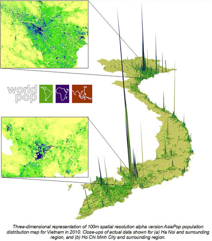
Briefly, the WorldPop method involves utilizing a range of open geospatial datasets that are combined in a flexible regression tree framework to reallocate contemporary aggregated spatial population count data. Statistical assessments suggest that the resultant maps are consistently more accurate than existing population map products, as well as the simple gridding of census data. Moreover, the 100 m spatial resolution represents a finer mapping detail than has been produced at national extents, and the integration with household survey, microdata, satellite and other data sources enables the production of more than simply population count estimates - age structures, births, pregnancies, poverty and urban growth are all mapped, with further variables under production. Most recently, consistent and comparable global data sets are now available from 2000-2020 at 100 m spatial resolution. These data products include total population as well as sub-demographic data on sex and age.
More information on methods as well as data sets and publications are found on the main website: http://www.worldpop.org.uk/about/
